Fectio
Index


|
|

click here
|
Ermelo 
January 2001(and later) |
Ermelosche Heide
Roman Temporary Camp |
  |
(Lees de pagina in het Nederlands )
On the
Ermelosche Heide lies the only example of a Late Roman
marching camp in The Netherlands. I grew up quite near
this site, but it took a long time before I actually
visited it being 'aware' of it. I mean, I crossed the
site many times before - by car, walking the dog, on a
bike trip, but never really looked at it. As a
young boy, I was told about the 'Roman Camp' on the
Ermelosche Heide (Ermelo Heath) and, as boys do, I
fantasised about high ramparts and all kinds of remains
which were bound to be found if you would just dig a
small hole. The plain field must have been disappointing,
because I never went back for about fifteen years. I
mean, the site is unimpressive to the casual
visitor and most difficult to find if you have no clue
about it; when I went to look for it in 2000 I completely
missed it, even took shots of other bumps in the heather!
But when you know what to look for, however, and come
with a bit of knowledge about Roman remains, the site is
still impressive, in the way that you can still see it
where all Roman stone buildings have been long gone. I
mean, it's the single Roman structure in these parts
still visible without any human interference, and that
when it was meant to be a temporary structure!

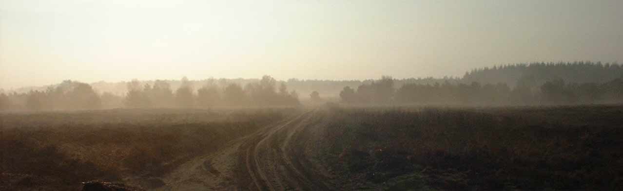
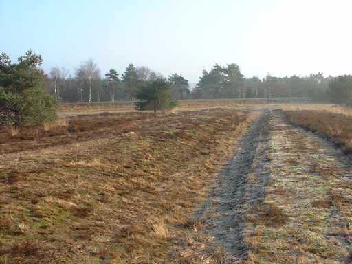
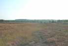
The Ermelosche Heide on a bright January morning
The
Camp
The camp
is the only known example of a Late Roman marching camp.
There will of course have been others, but these have as
yet eluded discovery and excavation.
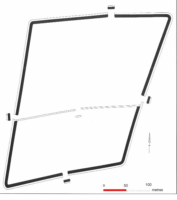
It measures 9 ha. (250x350m) large, surrounded by a wall
almost 1 metres high and a ditch which was 1.5 deep. It
was researched in 1922-3 by J.H. Holwerda, who dated
several pottery fragments to the 4th century. In 1987 the
ROB dug here again when a pipeline was constructed, and
R.S. Hulst re-dated the camp to the late 2nd century AD
by reassigning Holwerda's fragments to the later 2nd
century, confirming this through the dating of organic
material, which gave a period centred around the mid-2nd
century AD. An even more secure dating was aided by a
fragment of terra sigillata type Dragendorf 31,
which dates this fort to 170-80. It all added up to the
conclusion that the camp was used for a few days only.
This was also confirmed when a new look at the inner
ditch, which once separated the lower third of the camp
from the rest, showed that it was filled in almost
immediately after it was dug, probably during the initial
stages of construction. This was probably done to enclose
a natural hillock within the defences, which may be why
the camp shows its irregular form with a protruded point
to the south-west. The initial ditch which had a gate was
still V-shaped and showed that even the turf was put back
on top of the re-filled earth. The fort is scheduled, and
even a long use of the terrain by the Dutch Army (as an
armoured vehicle training ground) seems to have done no
more damage than shredding the SW corner of the fort. A
model of the fort and more information can be found in
the Veluws Museum in the nearby town of Harderwijk.

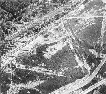
Aerial picture of the site, with the red line
showing the walls under the forest. |

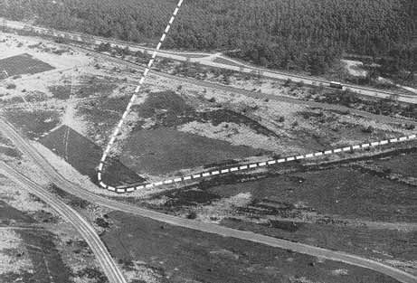
Aerial picture of the visible part of the camp. |

This aerial shot clearly shows the hillock in the
SW corner of the camp. |
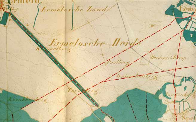
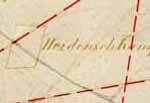 Why was this camp built here, on
the northern fringes of the Veluwe, which was until the
19th century a very poor area, and largely empty during
Roman times? The spot itself may be telling, because it
sits right on top of a ridge which separates the east
coast of the Flevomeer (Lake Flevo, a Roman name) from a
low valley to the east. A 19th-c. map (Click the image to
enlarge) shows that,
contrary to today's conditions, the area may have been
bare, with views for miles all around. The map shows the
Ermelo heath (Ermelosche Heide), south of a
sandy area which was even more bare (Ermelosche Zand).
It also shows the tops of nearby hills, showing the
strategic ridge, which was probably an ancient road as
well. Marches and forests in the valleys may have made
this a kind of natural ridgeway. The shortest distance to
the Rhine is two days' march (36 kilometres, 22 miles) ,
and one day again to the Flevo, which was much smaller
back then. The fort, not alluded to Romans but still to
pagans (Heidensch Kamp), clearly controls
several routes, crossing a line of hills (five names with
-berg), thus showing why this spot was chosen. Why was this camp built here, on
the northern fringes of the Veluwe, which was until the
19th century a very poor area, and largely empty during
Roman times? The spot itself may be telling, because it
sits right on top of a ridge which separates the east
coast of the Flevomeer (Lake Flevo, a Roman name) from a
low valley to the east. A 19th-c. map (Click the image to
enlarge) shows that,
contrary to today's conditions, the area may have been
bare, with views for miles all around. The map shows the
Ermelo heath (Ermelosche Heide), south of a
sandy area which was even more bare (Ermelosche Zand).
It also shows the tops of nearby hills, showing the
strategic ridge, which was probably an ancient road as
well. Marches and forests in the valleys may have made
this a kind of natural ridgeway. The shortest distance to
the Rhine is two days' march (36 kilometres, 22 miles) ,
and one day again to the Flevo, which was much smaller
back then. The fort, not alluded to Romans but still to
pagans (Heidensch Kamp), clearly controls
several routes, crossing a line of hills (five names with
-berg), thus showing why this spot was chosen.
Origins
of the camp
Of the
reason for building this camp we can but guess. Erected
in a very short time, it probably housed a large force of
Roman soldiers up to several thousand strong. It may not
seem much when compared to the 56 ha. of Xanten or the 42
ha. of the Nijmegen castra, but one should not forget
that these garrisons were built for two legions and their
auxiliaries. For a temporary camp it's certainly big
enough to accommodate a Legion. Since the best candidate,
the Legio X Gemina from Noviomagus/Nijmegen
was removed in 105 AD, maybe we should look to Legio
IX Hispana, which disappeared from Britain after 120
AD. The Ninth, or at least a detachment, undertook
repairs at Nijmegen during this period. Maybe there was
no legion present at Nijmegen, which would mean that the Legio
XXX Ulpia Victrix, present at Xanten from 120 AD,
would be the best candidate. Another possibility would be
the XXII from Mainz (see below). However, this
is by no means sure as there is no corroborating evidence
from a written source about a campaign in this area.
Was the camp maybe only for spending the night in enemy
territory? Or was it meant as a short-time support base,
to be abandoned when the campaign was over? Archaeologist
R.S. Hulst proposed that it supported aggressive
reconnaissance of the Veluwe, or that is was built for
the troops to get experience, in which case this was in
essence a training mission. I do not agree with that last
idea, the times were not right for that. This was the
period of the Marcomannic Wars, with all kinds of
troubles in the Danube region and even invasions of the
Italic heartland. However, no source reports any campaign
in Germania Inferior, pre-emptive or punitive.
We can
attempt to reconstruct a bit of history. After the death
of Marcus Aurelius (161-180 AD) the area seems to have
been gone up in flames. The Historia Augusta
tells us that Didius Julianus (Emperor for two short
months in 193 AD) had been a praetor before
commanding the XXII Primigenia at Mogontiacum/Mainz
and becoming ruler of the Belgian provinces. It is told
that he resisted with hastily levied auxiliaries the
Chauci , who had apparently raided the coast (they lived
around the Elbe), but who also managed to do severe
damage to cities such as Doornik, Arras, Thérouanne and
Bavay, which had to be rebuilt in the last quarter of the
2nd century. A camp of these auxiliaries has been found
at Maldegem, constructed around 173 AD and accommodated a
troop of Tungrian horse. It has been supposed that the
Ermelo camp represents a thrust in the back of the Chauci
to prevent or stop the raiding, with a move across land
to their area.
I have my doubts about this solution. It's a very long
haul that way to the Elbe, and we know the raids took
place. The Maldegem fort is certainly not as big as the
Ermelo one. What's more, although one can look at the
Chauci as proto-Vikings and thus explain their impact,
there may be more to it. The Ermelo camp is situated
north of the Rhine and the Limes, in the heartland of the
Chamavi. Did they move south to raid the important
thoroughfare of the Rhine frontier? The fort at Trajectum/Utrecht
was certainly rebuilt in stone (though only in 210), so
maybe the Chamavi were involved as well. We know this
period is the start of the emerging super-tribe of the
Franks, which was a coalition of such tribes as the
Salii, Chamavi, Bructeri, Amsivarii, Tubantes and
Chattuarii. Altough the Franks emerged as a coherent
group only during the 3rd century, the troubles of the
late 2nd may have foreshadowed this development. The Historia
Augusta tells us that Didius Julianus crushed the
Chatti, who may be the same as the Chattuarii, and
neighbours of the Chamavi.
Maybe Didius Julianus took his old Legion, the XXII, deep
into the lands of the Chamavi, to teach them a lesson?
His actions, whatever they were, certainly aided his
career: he was a rewarded with a consulate. It surely
helped him reach the purple for those two short months in
193 AD.
Whatever
the reason for the this camp, which we can but guess at,
it certainly shows that the area had an aggressive
commander such as Didius Julianus, whose campaign into
'Free Germany' may have succeeded or failed, but left us
this beautiful camp on the Ermelo Heath.
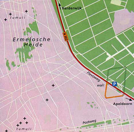
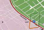 Visiting the camp Visiting the camp
(Click
the map to enlarge) The camp lies
south of the Flevoweg (N302). Coming from the east
(Apeldoorn or A1), you can easily park at the parking
lot, but remember that if you come from the west
(Harderwijk, A 28) you aren't allowed to turn: best turn
at the nearest intersection. There's a lot of traffic,
usually going fast - take care.
There is no path from the parking lot to the site, best
cross at the northern exit, this is directly across from
where the ditch starts, and you'll see the green
information column quite clearly. You need to cross the
hard shoulder and a shallow ditch, and step over a low
fence, before reaching the cyclepath.
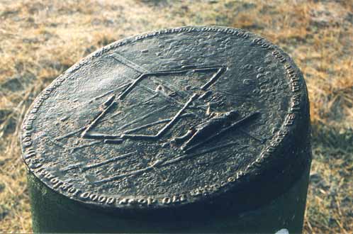
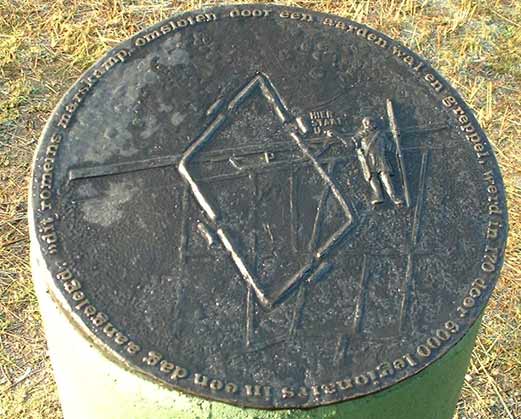
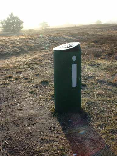
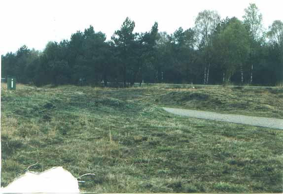
Here you'll find the bright green information column,
with a plaque on top with a text and a map. You are now
at the northernmost (visible) point of the west wall.

January 2001: The plaque of the information
column. The text says: |

"This marching camp, defended by an earthen
wall and ditch, was erected in 170AD by 6000
legionaries in one day". |

The information column. |
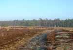
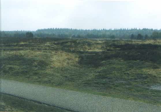
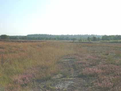
The bank becomes irregular when you are close to
the SW corner. |
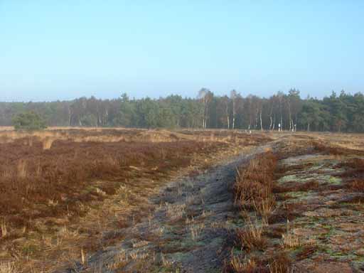
At this point you can easily see the bank
and ditch running south, as they are clearly cut by the
cyclepath. The bank and ditch are very well defined here,
and run south to the treeline.
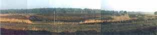
The fort as seen from the SW corner, looking NE. |

Back to the road across a well-defined ditch. |

Nearly there, I hope you enjoyed the tour. |
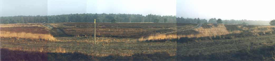
Follow
the ditch in a straight line to the first tank track, a
wide lane of sand. You may have lost track of the ditch
already, but if you walk in a straight line, you should
arrive at the SW corner of the fort. When I visited,
there was a large pole stuck in the ground which marked
this spot (probably as an aid to the drivers of the
armoured vehicles), as can be seen in the spread above.

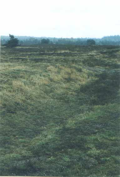
April 2002. The ditch can be seen to start here,
running south. |
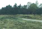
The cyclepath clearly cuts through the bank,
looking north. |

Bank and ditch clearly visible. |
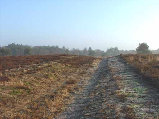
Now follow the ditch back to the road. It
may seem like an ordinary track, but when you know what
you're looking at are the bank and ditch, it can be
easily followed back to the road. Bank & ditch are
lost from view when they enter the forest.

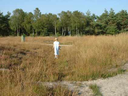
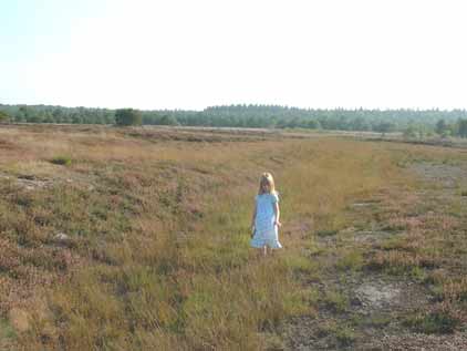
August 2003: my daughter Marrit walking through
the ditch near the information column. |
Looking south through the ditch towards the
forest. |

Marrit inside the ditch to give some perspective
on the shallowness of the ditch. |
Bibliography 
- Ginkel, Evert van
en Koos Steenhouwer (1998): ANWB Archeologieboek
Nederland (ANWB).*
- Hegener, M. (1995): Archeologie van
het Landschap, Langs de Aarden Monumenten van
Nederland (Contact).*
- Hulst, Rudi (1997): Ermelo, een
militair bivak op Germaanse grond, in: Dockum, S.
van en A. Haytsma: Archeologische Monumenten in
Nederland, (ROB, Abcoude), pp. 30-1.*
- Lendering, Jona (2000): De Randen van de
Aarde, De Romeinen tussen Schelde en Eems (Ambo,
Amsterdam).*
- Rijksdienst voor
Oudheidkundig Bodemonderzoek ROB (1997): Archeologische
Monumenten in Nederland, (Uniepers Abcoude).*
- Tilmann, Bechert en
Willem J.H. Willems (1995): De Romeinse Rijksgrens
tussen Moezel en Noordzeekust (Konrad Theiss
Verlag).*
|