What's New I Sitemap I Bibliography I Vortigern Studies l POLLS I LINKS l Games I Sitemaster |
What's New I Sitemap I Bibliography I Vortigern Studies l POLLS I LINKS l Games I Sitemaster |
| Vortigern Studies > Fectio > Roman Sites > Caesarea 1990 |
Fectio Index
|
Towards the end of our holiday in Israel, we wanted to visit the ruins of Caesarea. The girls had some stuff to deliver in Haifa, so Menno and I once again went our separate ways to sniff some Roman culture. Caesarea, or 'Che-saa-ria' as they seem to pronounce it loclly (a bit Italian-like) still is very impressive, and has a very grand but short history.
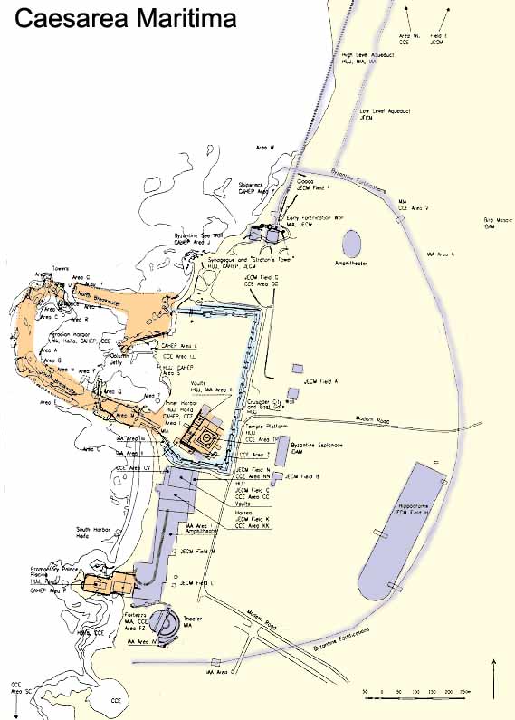
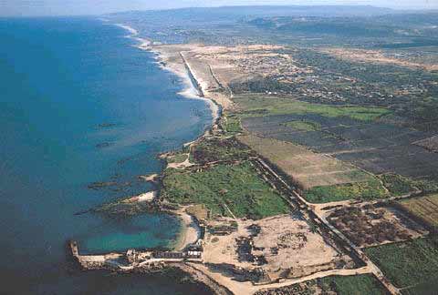
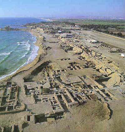
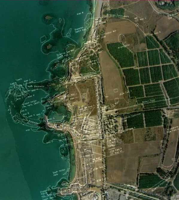
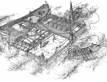
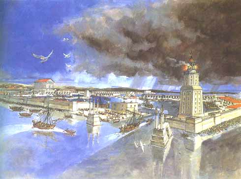
Caesarea Maritima Caesarea is located on the Mediterranean coast, about midway between Haifa and Tel Aviv. Archeological excavations during the 1950s and 1960s uncovered remains from many periods, in particular, a complex of fortifications of the Crusader city and the Roman theater. Founded as a colony of Phoenician Sidon in the 3rd century BC named Straton Tower, it remained a less important settlement. Until the arrival of Herod the Great that is, who built a great harbour from 22 to 10 BC, forever changing the destiny of the town. Herod named it Caesarea in honour of Augustus Caesar. The historian Josephus Flavius, who was born around 7 or 8 CE, published a history of the Jewish people in 93-94 AD. This work contains a detailed description of the city of Caesarea and its harbour, Sebastos, and its development by Herod, as he built palaces, a temple, an amphitheatre, public buildings, a market place and a deep sea harbour: Flavius
Josephus: Antiquitates Judaicae (The
Antiquities of the Jews) Book
XX, Chapter 4.4: Flavius
Josephus: Antiquitates Judaicae (The
Antiquities of the Jews) Book
XV, Chapter 9.6: The Roman City In the year 6 AD, Caesarea became the seat of the Roman procurators of Provincia Judaea and headquarters of the 10th Roman Legion. In the 2nd and 3rd centuries, the city expanded and became one of most important in the eastern part of the Roman Empire, classified as the "Metropolis of the Province of Syria Palaestina." After Herod's death, Caesarea became one of the leading maritime cities. Such was its splendour that in 6 AD it became the seat of the Roman procurators of Judaea. When the great rebellion against Rome broke out in 66 AD, it started in Caesarea. Violence broke out between the city's Jewish and Syrian communities, and up to 20.000 Jews were killed. This massacre sparked the nationwide Jewish revolt against the Romans, who used Caesarea as their headquarters in the reconquest of Palestine. After the war, the Emperor Vespasian made it a Roman colony and the capital of Palestine, now that Jerusalem was razed. Caesarea remained the capital for almost 500 years. The temple of the city, dedicated to Augustus Caesar, was built on a high podium facing the harbor. A broad flight of steps led from the pier to the temple. Public buildings and elaborate entertainment facilities in the imperial tradition were erected. King Herod’s palace was in the southern part of the city.
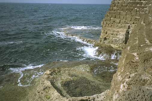
The palace was built on a rock promontory jutting out into the sea, in the southern part of the Roman city. The excavations revealed a large architectural complex, measuring 110 x 60 m., with a decorative pool, surrounded by porticoes. This elegant structure in its unique location was identified as Herod’s palace. (Antiquitites, XV, 332) The palace was in use throughout the Roman period, as attested to by two columns with Greek and Latin dedicatory inscriptions naming governors of the province of Judaea.
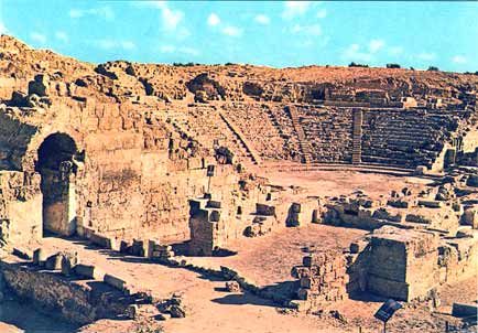
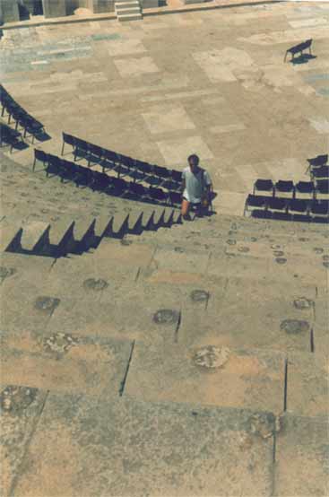
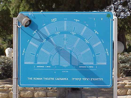
The theater is located in the very south of the city. It was commissioned by King Herod and is the earliest of the Roman entertainment facilities built in his kingdom. The theater faces the sea and has thousands of seats resting on a semi-circular structure of vaults. The semi-circular floor of the orchestra, first paved in painted plaster, was later paved with marble. In the excavated theater a stone was found, bearing parts of an inscription mentioning Pontius Pilate, Procurator of Judea, and the Tiberium (the edifice in honor of the Emperor Tiberius) which he built. The amphitheater, on the city’s southern shore, was north-south oriented and measured 64 x 31 m. Its eastern and rounded southern side are well preserved; the western side was largely destroyed by the sea. A 1.05 m-high wall surrounded an arena, covered with crushed, beaten chalk. When first built in the Herodian period, it seated about 8,000 spectators; in the first century AD seating areas were added, increasing its capacity to 15,000. The dimensions, shape and installations indicate that this amphitheater was used for racing horses and chariots and was, in fact, a hippodrome. During the second century, the amphitheater was rebuilt and adapted for use as a more standard type of amphitheater.
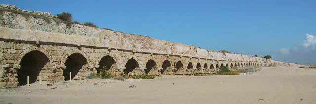
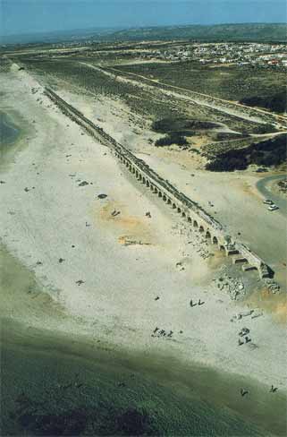
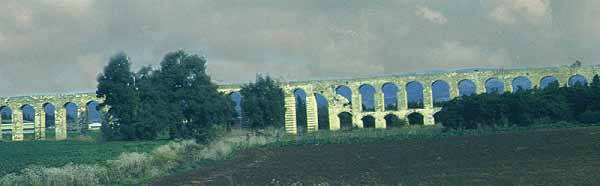
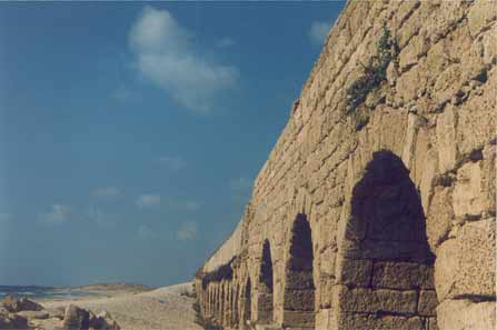
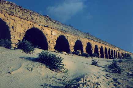
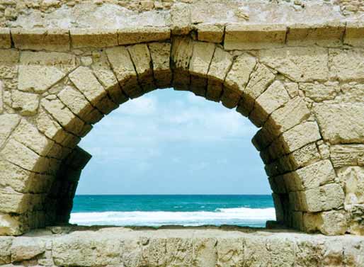
The Aqueduct, which provided an abundant supply of water, was built in the Herodian period; it was later repaired and enlarged to a double channel when the city grew. The upper aqueduct begins at the springs located some nine kilometers northeast of Caesarea, at the foot of Mt. Carmel. It was constructed with considerable engineering know-how, ensuring the flow of water, by gravity, from the springs to the city. In some portions, the aqueduct was supported by rows of arches, then it crossed the kurkar ridge along the coast via a tunnel. Entering the city from the north, the water flowed through a network of pipes to collecting pools and fountains throughout the city. Many inscriptions in the aqueduct ascribe responsibility for its maintenance to the Second and Tenth Legions.
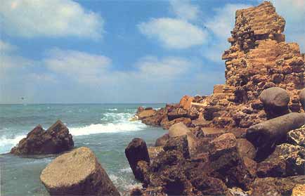
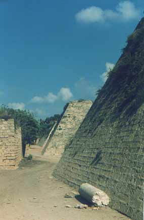
The great harbour already began silting up during Roman times, yet activities continued until the inner harbour completely silted up during the 6th century. As a result of changes in the coastline of Caesarea, Sebastos - the city's main feature - was lost. The sinking of the breakwater began the ongoing silting process of the inner harbor. Caesarea's inhabitants were forced to act in order to ensure the continued usefulness of the harbor. In accordance, during the 2nd and 3rd centuries, the Romans built a new pier attached to the center of the Herodian pier. However, the silting process continued and by Byzantine times this addition was of no further use. Byzantine Caesarea During this period, Caesarea became an important Christian centre. The Church Father Origen founded a Christian academy in the city, which included a library of 30,000 manuscripts. The main church was the Martyrion of the Holy Procopius, built in the 6th century upon the remains of the Roman temple on the podium. The octagonal, 39 m.-wide church stood within a square precinct measuring 50 x 50 m., surrounded by rooms along its walls. The floor was paved with marble slabs in a variety of patterns. Of the rows of columns in the building, several Corinthian capitals decorated with crosses were found. Byzantine Caesarea was surrounded by a 2.5 km. long wall, which protected the residential quarters built outside the Roman city. It had a 3 m.-wide city gate in its southern section. Side by side with the Christian population and its numerous churches, there were Jewish and Samaritan communities that built elaborate synagogues. During this period, the Roman inner harbor was blocked and buildings were constructed on what had become dry land. A row of vaults serving as shops was built against the podium wall facing the port. A very large and elaborate building, which included numerous courtyards and rooms spread over the area of an entire insula (block of buildings) and surrounded by the main streets of the city, was dubbed the government building. Its entrance was from the cardo (north-south main street), its western side supported by a row of vaults, which had once served as port warehouses. One such vault facing the decumanus (east-west main street) was plastered and decorated with red and black wall paintings, including depictions of Jesus and the twelve apostles. Remains of a 5th century synagogue were found on the seashore north of the harbor. The rectangular building faces south towards Jerusalem. Architectural details were found in its ruins, including capitals with carved menorot (candelabra), a column inscribed shalom and parts of a Hebrew inscription listing the twenty-four priestly courses in the Temple in Jerusalem. Inside the amphitheater, which was no longer in use, a two-level palace was built with a staircase connecting the two levels. The upper level included two courtyards and rooms paved in colored tiles or mosaics and served as the residence. The lower level had a courtyard with an apse on one side, paved in colored tiles. Along this courtyard stood two rows of columns with a marble chancel screen between them and in the northern wall was a fountain with a rectangular basin below it. This lower level served as an open garden. Arab Caesarea The end of Caesarea as a main city resulted from the destrcutive wars between the Byzantine and Sassanid empires during the 7th century. The Sassanid Persians conquered the city and ruled it for 14 years. Shortly after its reconquest by the Byzantines, Arab forces lay siege for 7 years, finally conquering the town in 640 AD. Thereafter, the town declined in importance, although it remained a flourishing harbour. Urban areas were abandoned and replaced by agricultural terraces. This Arab town was surrounded in the 10th century by a 3 m.-thick wall. Caesarea of the Crusaders With the onset of the Crusades, Caesarea fell to Christian forces again in 1101, in the form of the Frankish army under King Baldwin I. Caesarea became the seat of an archbishop and not only Franks but also eastern Christians and Muslims settled there. The Genoese found a green-colored glass vessel in the city and declared it to be the Holy Grail, the goblet used by Jesus at the Last Supper. It was taken to Genoa and placed in the Church of San Lorenzo. By in 1187 Saladin reconquered it again, but it was retaken in 1191 by Richard the Lion Heart, King of England, who exiled the Muslim inhabitants. Over the following years, Caesarea changed hands a number of times, returning to Christian domination in 1228. Louis IX built the currently visible walls in 1251, and a magnificent 4 m.-thick wall, some 1.6 km. long, surrounded the city, which covered an area of about 40 acres. It was also protected by a glacis, towers and a 10 m.-deep and 15 m.-wide moat. The cathedral of the Crusader city was built on the podium raised by King Herod to serve as his city’s acropolis. The 12th century cathedral, the eastern part of which was added in the middle of the 13th century, was a modest structure measuring 55 x 2 m. The hall was divided into a central nave and two aisles that ended in the east in three apses; the floor was paved in mosaics. The vaulting was supported by rectangular piers and pilasters.
However, Caesarea was taken by Sultan Baibars in 1291. After a short siege, the Crusader defenders gave up hope and evacuated the city. The Mamluks, fearing yet another European Christian army would attempt to set foot in Palestine, finally destroyed the city and filled in the harbour. Caesaerea remained a deserted ruin for centuries. Only in 1884, a fishing village was founded on the site by Muslim refugees from Bosnia. It was later taken over by the Arabs and abandoned in 1948. The area was developed with the help of the Rothschilds, and it has become a leading resort area and retreat for the rich. Today, it is fast being developed in yet another coastal town.
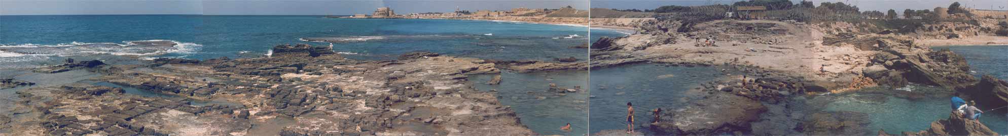
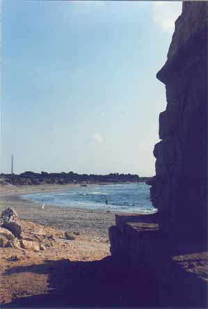
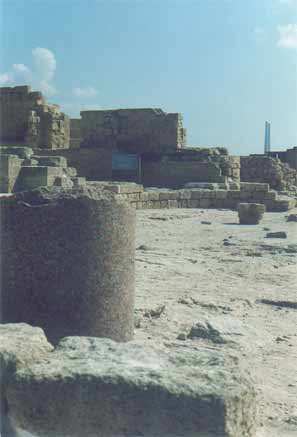
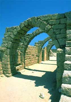
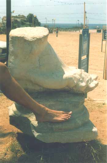
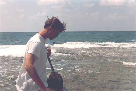
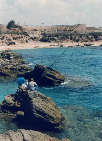
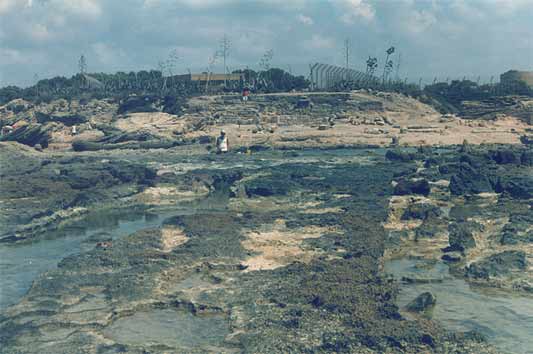
The Visit Menno and I went by bus from Netanya, and it took us a bit of asking around to get the right one. Apparently, Caesarea was not as popular with the tourists as we had expected. Which was fine with us, because it meant we pretty much had the place to ourselves once we got there. Well, 'to ourselves' may be an understatement. It was rather desolate. Sure, there were some people around - apparently there was an archaeological dig going on, as well as reconstruction work on the ruins, but that was about it. Driving up there, through the shrub and orchards that line the coast, there was not a soul in sight. Maybe it had something to do with the time of day, or the temperature? It was hot. Very hot. I should insert a small note here before moving on with my description of our visit. As I'm writing this, I realise the site has changed a lot since 1990. Vast areas of the ruins have been 're-done', such as the area between the amphitheatre and the Crusader town. There is a new access road as well, so some details of my description will surely sound alien to modern readers. My apologies. Time does not halt for memories. Which is a bit what I feel, looking back. Of course, when we arrived at the town the emptiness was surprising, but when we started exploring the place, that feeling changed. It was clear, we soon found out, that Caesarea was in full swing! Meaning, there was building activity all over the place. We bought a few older postcards and soon noticed we'd missed some romantic ruins, which now radiply were replaced by smooth, slick reconstructions. The amphitheatre was already completely 're-done', and had already seen some big productions.. OK, you say, nothing new, the did that at Xanten in Germany, as well as Augst in Switzerland, and all over the Meditterranean. It serves to use the ruins and catch the big money as well as the public, and, if possible, prepare the heritage. However, with its neat, clear rows of seats, it somehow looked out of place, almost modern. So far, so good. We moved on towards the sea. What remained of Herod's Palace, and of Pilate's and every other Roman procurator's palace as well, was a waves-swept terrace, barely above sea-level, with a grand view of the city. Of course, we had to climb a fence, for some impolite person sneered at us that "the nice rocks were to be found elsewhere". We ignored him and proved him wrong, as the pictures show. We then ventured along back through the town, because the beach was cordoned off, too bad. A hefty trip in the increasing heat, but we arrived at the inner city, now recognisable as the Crusader Town. There was a nice shade and we hid for some time in the old vaults to cool down a bit, before nearly getting lost in the moat! Sliding down, we did not immediately found a way out again (stupid) and walking the whole moat back was not particularly appealing! Not appealing either were the ugly-looking touristic stands which now dominated the Crusader town, and after a quick check of the remains of the southern breakwater, we left for the aquaduct. Now, that was a hefty walk! Seven kilometres through the heat, across a sandy and dusty track. But it was worth it. The aquaduct, still unspoilt by modern work, looked really old, the way it should. Half-buried arches which once carried tons of water, now broken by the waves. Impressing. Very hot, too, we did not stay long. Too bad the view south was spoilt by the big coal-powered plant at Hadera, with its big pipes..
|
VortigernStudies is copyright © Robert Vermaat 1999-2011. All rights reserved |